New Geology hiking guide published on this website: Ridley Creek Trail, Mount Baker

Link to Ridley Creek Trail geology guide:

https://nwgeology.wordpress.com/the-fieldtrips/ridley-creek-trail-geology-guide/

Foot bridge over the Middle Fork

Foot bridge over the Middle Fork

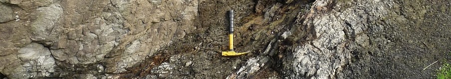
Ridley Creek Trail begins at the end of the Middle Fork Nooksack Road on the southwest flank of Mount Baker. The trail accesses the heather meadows of Mazama Park and on to Park Butte Lookout. Along the way see forested latest Pleistocene moraines, glacial till from Canada complete with quartzite pebbles from the Rocky Mountains, limestone, lahar and ash deposits, a close up of the Cathedral Crag lava that predates Mount Baker, and finally, great views of Baker, the Black Buttes, and that enigmatic slice of the mantle, the Twin Sisters Range. Read the geology guide here.  Enjoy!

Dave Tucker

Middle Fork Nooksack debris flows- another one, and an update

The Middle Fork has cut 10 m through the May 31 debris flow. Click to enlarge.

The Middle Fork has cut 10 m through the May 31 debris flow. Click to enlarge.

There is a description of ongoing dramatic changes to the new debris flow deposits in the Middle Fork Nooksack over on the MBVRC blog. There has been a second debris flow, on June 6th.

Debris flow update: http://mbvrc.wordpress.com/2013/06/12/more-debris-flows-in-middle-fork/

Comparative YouTube videos. June 9th  video shows major changes in only four days: http://www.youtube.com/watch?v=8cepN93zOY8

Compare with the June 5th YouTube video: http://www.youtube.com/watch?v=4vVJPPwLgwM

More on Middle Fork Nooksack debris flow

By Dave Tucker  June 7, 2013

Photo by John Scurlock. Explanation on the link to today's MBVRC blog post.

Photo by John Scurlock. Explanation on the link to today’s MBVRC blog post.

The source of the debris flow in the Middle Fork Nooksack River is now believed to be a large landslide rather than a glacial outburst flood. This is based on new aerial photos provided by John Scurlock and Steph Abegg. The updated post is on the MBVRC blog.

There is video I made when I visited the deposits two days ago. See it here on YouTube. Shows the extent of the debris flow deposit at the Ridley Creek ford.

And another YouTube video shows a volcanic debris flow [a.k.a. ‘lahar’] raging down a valley in Indonesia. It is probably similar to the Middle Fork flow, except considerably smaller.

There will be another visit to the deposit Sunday AM early by a geologic team to begin serious study of the deposits and to try to begin estimating volume, velocity and other parameters of the May 31 debris flow. There will probably be an update posted on the MBVRC blog, so if you don’t already subscribe to it, consider doing so.

Glacial Outburst Flood in Middle Fork Nooksack- May 31, 2013

NEWS ITEM

The 'hihg-mud mark' from the glacial outburst flood and debris flow is 20 feet above Bob's head. Click to enlarge.

The ‘high-mud mark’ from the glacial outburst flood and debris flow is 20 feet above Bob’s head. Click to enlarge.

A large flood of sediment and water swept the upper channel of the Middle Fork Nooksack River early in the morning of Friday, May 31. Boulders up to 10′ across were pitched onto a terrace 15′ above water level, and the river channel was buried in mud. A seismometer on Mount Baker picked up the tremor of the debris flow, and the sudden increase in river volume was detected on the stream gage at Nugent’s Corner, 25 miles away, a couple of hours later. The river is still very turbid. A report with photos is posted on the Mount Baker Volcano Research Center blog:

http://mbvrc.wordpress.com/2013/06/05/large-debris-flow-in-middle-fork-nooksack-river-may-31-2013/