

By Dave Tucker, January 22, 2010
This field trip visits Middle Jurassic metamorphic rocks immediately south of the Chuckanut Formation, in extreme northwest Skagit County, Washington. From Chuckanut Drive (WA highway 11) the hike ascends the Pacific Northwest Trail and branching trails to the top of Oyster Dome for a spectacular 180 degree view over the San Juan Islands, estuary flats of the Samish and Skagit rivers, and Olympic Mountains. A field guide to this hike was published in Babcock and Carson (2000); see references below. One or two of the geologic interpretations you read below will differ slightly from theirs.
The rocks of Blanchard Mountain (also known as South Chuckanut Mountain) are metamorphosed marine sediments and igneous rocks. For the best read on the geology, see Gallagher and others, 1988. These rocks are in the western part of the Shuksan Metamorphic Suite defined by Western Washington University petrologist Ned Brown and his various grad students over the years. This suite of rocks has been subsumed into Rowland Tabor’s Easton Metamorphic Suite, which is best known for the Darrington Phyllite and Shuksan Greenschist rock units in the North Cascades; rocks associated with the ones along this trail are patchily exposed as far east as Mount Shuksan, though they are sometimes covered by younger rock units. The rocks we will visit on this hike are different in a very important way from other rocks in the Shuksan/Easton Suite- they include intermediate plutonic rocks. A single U-Pb date has been obtained from zircon in a diorite a little east of Blanchard Mountain. This radiometric date implies that the rocks of Blanchard Mountain originated around 163 million years ago (Gallagher and others, 1988). These rocks are interpreted to have formed in an oceanic volcanic arc somewhere well to the west of the coast of North America as it stood at that time, and was later accreted to North America by subduction. Metamorphism was in the high pressure but low temperature blueschist facies, which corresponds to subduction environments. These rocks were subjected to temperatures of 330-400 degrees C and pressures corresponding to around 7-9 kilobars (20 kilometers, or 12 miles deep). Metamorphism took place around 120-130 million years ago (Brown, 1987).

- Engraved granite sign at the PNT trailhead on Chuckanut Drive.
Getting there: The popular trailhead is on Chuckanut Drive (WA State Route 11), just a few hundred feet north of mile post 10, and just south of the Oyster Bar restaurant. There are a couple of wide shoulders along the road for parking. Be cautious here, as break-ins have been reported. The hike begins on the wonderful Pacific Northwest Trail, which runs from the Olympic Coast at Cape Alava to the Continental Divide in Glacier National Park. The trail system on Blanchard Mountain was built and is maintained by an all-volunteer organization. Visit the PNTA for more information. The round trip distance to the top of the Oyster Dome and back is 7.6 miles; elevation gain is about 2000 feet. A good map showing trails is Trails of the Chuckanut Mountains by Ken Wilcox (Skookum Press), available in shops in the Bellingham area. I cite distances measured for this map in this field guide. For an on line map: go to the PNTA website, run your mouse over the ‘trail’ pulldown at upper left, click on ‘maps’ and choose the Blanchard Hill/South Chuckanut Mountain map. The trails we will use are the lower switchbacks of the PNTA (shown in red), the “Samish Bay Connection”, the “Talus Trail” and the “Rock Trail”. You could cheat and drive to the hangliders’ jump at Samish Overlook via Barrel Springs Road, then hike down along the PNT to the 1.6 mile junction, but you wouldn’t get as much exercise, and would lose virtue points. Your scribe will assume you are virtuous.
The trail starts right off from Chuckanut Drive with a steep grunt up through the forest. The hillside is all colluvium of phyllite or semischist- these rocks aren’t very competent, so outcrops tend to fall apart pretty easily. There is very little geology to see for the first mile or so, which is mostly in Douglas fir forest. After about 1 mile, there is a bench on a rock slab with a great view over the San Juan Islands at the far end of an older clearcut. The outcrop is semischist with vertical, E-W oriented foliation. Semischist isn’t something you hear about much, though it is a type of metagreywacke; you won’t read about in petrology textbooks or geologic dictionaries, but there’s a lot of it on Blanchard Mountain. It is a low grade metamorphic rock, derived from sandstone or medium-grained tuff. Semischist has foliation, but lacks the prominent minerals of ‘schist’ because the pressure-temperature facies (or regimes) that formed the rock were not high enough. It forms in the same metamorphic regime as phyllite, which is also abundant on Blanchard Mountain. Semischist parent rocks are coarser grained than the mudstone parent of phyllite, so the metamorphosed semischist is not as fine grained and shiny; semischist does not have the wavy or kinky foliation of phyllite, and is not veined with quartz as the local phyllite is. Semischist tends to cleave along parallel, flat foliation planes similar to the manner of slate, but foliation planes are not paper thin as they typically are in slate.

- The stretched pebble conglomerate is the slab at the near end of the big tree root. This view looks south, back the way you have come to get here.

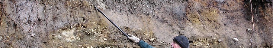
Shortly after the bench reach the junction where the PNT turns sharp right- go straight on the “Samish Bay Connection” trail. There’s a really cool, but very small, exposure of ‘stretched pebble conglomerate’ in a big root of a Doug fir growing in the trail. If you are hiking in the wet season, you should be able to hear a stream closely ahead, the first you will come to on this hike. The UTM for this place is E542270 N5384650; I always use NAD 1927 datum, and precision is ± ~ 20 m. The conglomerate is of part of the semischist rock unit, and was at one time a conglomerate of small pebbles. Rounded pebbles, such as these once were, require stream rounding, so they were apparently carried into the marine environment from the volcanic arc they were eroded from. The outcrop is subtle, and you have to watch for it. It lies at the north end of the big tree root, and is mostly buried with moss and slime. This rock has long pale-colored rods- these were pebbles prior to metamorphism during subduction. They didn’t ‘melt’ to get this way, but were just gradually stretched out by the insistent long-term directed pressure of subduction metamorphism. Within 200 feet after this slab, you will come to the first stream, often dry in summer, but unmistakable in any case. If you get here and haven’t seen the pebble conglomerate, backtrack until you come to the big tree root shown in the photo at left. Thanks to Scott Babcock for first pointing out this rock to me.

- The stretched pebbles are only a cm or so long; the foliation of the rock, as shown by the orientation of the stretched pebbles, is parallel to the pencil.

The next geologic point of interest is 3/4 mile further along, and unmistakable. You’ll hike up along a stream in a deep gully below you to the left; across the creek, you may be able to see a cliff. Cross the creek. This is the first significant stream crossing required on this hike; it may be dry in the summer. Just beyond are large knobs on both sides of the trail. (UTM E542850 N5385560). If you have a rock hammer, examine a fresh surface you smack off of one of the angular blocks lying along the trail. The fresh rock is fine grained and green, but even with a handlens and good light, it is pretty amorphous. This is an unfoliated low grade metamorphic rock called greenstone, and the glacially polished knobs to the west of the trail are made of it. The greenstone probably originally as a (submarine?) basaltic lava flow, part of the subducted arc that is preserved in these rocks, and subjected to the same metamorphic stress as the semischist and phyllite. A path to the left goes between two knobs; it is easy to get on top of the nearer little dome for a view, but the higher one a little further away is pretty steep. There is a dense cluster of uniformly ½” wide and ½- to 1” deep grooves on top of the near knob. Are these from glacial scouring? How is it they are so very similar? Are they even geological? You may find subtle clues along the trail farther along on the hike.

You KNOW this isn't Chuckanut, and what is meant by 'matrix' here? This sign is way overdue for replacement.
There will be a steep grunt up phyllite slabs; you’ll then come to another big greenstone knob. If you are using the Wilcox map, this place is labeled ‘Rumble Rock’. Here is a curious ‘interpretive’ sign labeled ‘The Ice Age’. My mother told me “If you can’t say anything nice, don’t say anything”. But I can’t quite resist. You’ll know the geologic sins that this sign is guilty of as soon as you read it. You may not know what regolith is, though. It is unconsolidated rocky material, like the colluvium you hiked through at the very start of the trail. Carried along under a glacier, it is the material that erodes away or grooves and polishes solid rock, such as the greenstone domes. Regolith doesn’t really ‘rumble’ as the sign says. The sign needs to be removed and replaced with something more accurate. Very fine views from the top of the knob are surpassed only by those at the top of the Oyster Dome.

The west face of the Oyster dome rises above the Bat Caves. Yes, there are climbing routes here.
You may have noticed that the glacial till, filled with rounded pebbles, has become more and more prevalent along the trail. You won’t miss that as you go a little farther. Only a hundred yards or so after ‘Rumble Rock’ the trail suddenly turns almost straight uphill, and quickly comes to the ‘Talus Trail’ junction. Go left here to reach the Bat Caves; be wary of the rickety plank bridge across the creek. It is slimy and shaky, and you may prefer to cross the stream by going under the bridge. The stream itself cascades over phyllite in contact with greenstone. The talus of huge blocks that contain the Bat Caves is quickly reached. These fell from the 200-foot-high west face of the Oyster Dome, towering above you. Let’s discuss the rock of Oyster Dome on top. However, you may want to grab a little piece to contemplate once you are up there- try to get a freshly broken surface. Did these house-sized talus blocks accumulate one by one, or did the west face collapse all at once? What would cause that? A big earthquake? We don’t know. In any case, if the rock isn’t too slimey, it is possible to go down under some of the talus blocks, but only do so if you have a hardhat and two flashlights. The caves are very contorted, with an infinite number of branches. It is possible to crawl for hundreds of yards, but it is wet, muddy, and very constricted. The caves are home to rare bat species; if you see any bats, steer clear.

Ken Wilcox points out the scenery in this view to the southwest from the Oyster Dome over Samish Bay.
Return back across the funky bridge to the main trail. The next two hundred yards are the hardest of the entire trail, climbing very steeply on sometimes slippery till to the end of a logging railroad grade- note the twisted “iron horse” track at the top of the grunt, and plenty of rusting logging cables. The railroad grade is the continuation of the main trail, heading toward Lily Lake. Early in the 20th Century, engines and track were winched up the ‘Incline’, on the other side of Lizard Lake. Turn left when you reach the flat railroad bed, and head down to the creek on a well-worn trail. Across the creek, the trail goes to the bare sloping slabs of the Oyster Dome in less than 1/4 mile, giving great views out to the San Juan Islands and southwest to the Olympics. The rock is coarse grained metadiorite. Diorite is an intrusive igneous rock that cooled slowly in a magma chamber within the crust- it is the plutonic equivalent of andesite. The glacially smoothed, unfractured slab doesn’t lend itself to sampling. If you want to look at a rock sample, the Bat Caves talus is the place for that.
Let’s put the whole geology together for this hike. This draws heavily on interpretations in Brown (1987) and petrology in Gallagher and others (1988). Around 163 million years ago, the sediment that eventually became the phyllite and semischist of this rock suite was being deposited on the sea floor of either the Farallon or Kula oceanic plate (the Juan de Fuca plate is a tiny remnant of these). At the same time, lava flows were erupted on the seafloor, and eventually grew high enough to form one or more islands in a volcanic arc. Magma continued to rise; some erupted, but the rest cooled within the crust to form the diorite. The seafloor was moving generally to the east, away from a spreading center further out in the ocean due to plate tectonics- this is analogous to the current situation off the coast of Cascadia. Eventually the conveyor belt of seafloor, with its piggyback load of volcanic islands, encountered the western margin of North America. As the seafloor was subducted, the thick chunk of the seafloor and its volcanic load got stuck in the subduction zone around 12 miles (20 km) down; it was too thick to continue downward on the subducted oceanic plate. The subduction fault broke on the seaward margin of this suite of sediment and rocks, so that subduction jumped to the west. Consequently, these rocks were accreted to the leading edge of North America. Pressure from burial, and from lateral pressure due to ongoing subduction to the west, metamorphosed the sediment and igneous rocks to the ones we see today, changing some of the minerals to the chlorite minerals that make the greenstone green. Uplift and erosion have exposed them. They were covered by Chuckanut Formation at one time, but all that is gone from Blanchard Mountain. For an overview of this sequence of events, see Brown (1987).
References:
Babcock, S., and Carson, B., 2000, Hiking Washington’s Geology, The Mountaineers, Seattle. OUT OF PRINT.
Brown, E.H., 1987, Structural geology and accretionary history of the Northwest Cascades system, Washington and British Columbia: GSA Bulletin, v. 99, p. 201-214.
Gallagher, M.P., Brown, E.H., and Walker, N.W., 1988, A new structural and tectonic interpretation of the western part of the Shuksan blueschist terrane, northwestern Washington: GSA Bulletin, v. 100, p. 1415-1422. Available online at:
http://myweb.facstaff.wwu.edu/bernieh/reprints/brown-gsa-cord-07-san-juans.pdf

[…] and hike up two miles of switchbacks before they hit the trail that will start to take them up to Oyster Dome. I like to park at the Samish Overlook and hike the loop […]
[…] Whatcom County, is an excellent place from which to view the San Juan Islands as well as an area of geological interest. Fortunately, for those like me who don’t like crowds, getting there and back […]