

By Dave Tucker. Hiked June 24, 2015. Thanks to J. Call for the company. Written July 15, 2015.

Debris flow warning sign at the Ridley Creek trail head. Placed by US Forest Service after two dangerous debris flows filled the Nooksack’s channel with deep mud and large boulders. Click to ENLARGE any image.
The following field guide is an excerpt from Mount Baker Road and Trail Geology Guide, a book I am writing.
If you want to print out this guide, go to this page (elsewhere on my website) for a how-to suggestion.
References are listed at the end of the guide.
The Ridley Creek Trail begins at the end of the Middle Fork Nooksack Road and ascends through old growth into heather meadows of Mazama Park, and beyond to the immaculately restored Park Butte Lookout. Geology along the route includes a sharp-crested late Pleistocene lateral moraine, glacial till with stones from the Rocky Mountains of British Columbia, deposits from two different Holocene lahars, bouldery debris left behind by collapse of the terminus of Deming Glacier in June, 1927, volcanic ash from both Mount Baker and Mount Mazama (Crater Lake caldera), and lava erupted from volcanoes predating Mount Baker. While crossing the Nooksack River flood channel, you are in the path of debris flows such as the ones that blanketed the channel in May and June, 2013 (link to MBVRC reports on these events).
Getting there: Reach the Ridley Creek trail head from the Mount Baker Highway (State Route 542). Seventeen miles east of I-5 exit 255, turn right at the community of Kendall onto Mosquito Lake Road. In another 4.8 miles veer left at Porter Creek Road, which becomes the Middle Fork Road (Forest Service Rd 38). This good quality gravel road ends in 13 miles at the Ridley Creek trail head. DISTANCE: 4 miles on the Ridley Creek trail to the junction with the Park Creek trail (coming out of Schriebers Meadow) and another 3/4 mile up that trail to the Park Butte Lookout. The trail head is at 2660′. Elevation gain: 2200′ to the junction, another 600′ to the lookout. MAP: use the Green Trails Mount Bker Wilderness Climbing Map 13S. It shows the trail but the length on the map is not accurate.The USGS Twin Sisters and Baker Pass 7.5 minute quads show the trail very inaccurately. Distances are from a GPS track I made with my Garmin 62s GPS receiver. I trust ’em.
Geology Guide:

The Ridley Creek trail. Black squares are 1 km. Trailhead is on the extreme left (west). Waypoints mark some locations mentioned in the description. Note the 0.25 mile scale at lower left. Click to enlarge. GPS track by D. Tucker, 6-24-2015.
The trail head and first hundred yards of the trail are on the forested surface of the 5700-year-old Middle Fork Nooksack lahar (field trip guide). This is the largest lahar in the geologic record at Mount Baker. It began with the collapse of a large section of the volcano on the Roman Wall, the headwall of the Deming Glacier. The deep-seated debris avalanche (also known as a volcanic landslide) consisted of a large volume of stacked lava flows and breccia as well as the overlying glacial ice. The debris landslide rapidly transformed into a highly mobile wet concrete-like slurry of mud, rocks and water. The lahar traveled down the Middle Fork to the North Fork Nooksack at Kendall, and onward past the sites of Deming and Nugents Corner. It probably reached the Fraser River beyond Abbotsford BC after flowing down the Sumas River. The Middle Fork lahar left over 30 feet of boulders, mud, and logs at the highway bridge across the river at Nugents Corner (covered by more recent alluvium).
The trail descends through the poorly exposed Middle Fork lahar deposit and reaches a narrow band of younger trees and giant boulders immediately before reaching the river bed. Tree cores date the largest trees on this low terrace to 1927- the year that eyewitnesses reported a giant flood carrying house-sized blocks of ice and boulders down the river. This event was likely caused by the collapse of the stagnated terminal km or or so of the Deming Glacier, releasing a huge volume of water in a glacial outburst flood (also known by the Icelandic word jökulhlaup pronounced yo-kul-yuip). Deposits are recognized as far down stream as the Elbow Lake trail crossing. Note meter+ sized boulders and scarred trees at the top of the bank you descend to the river- these are from the May 31 2013 debris flow, which slopped mud and banged logs and rocks onto tree trunks as high as 6 feet above the bank.

The view up the Middle Fork at the trail crossing. The white summit dome of Baker peeks out beyond glacially-gutted remnants of the Black Buttes volcano.

Foot bridge over the Middle Fork
Pick your way across the boulder-strewn channel of the Middle Fork, 0.2 mi from the trail head, aiming for the foot bridge built by volunteers in 2014. (And you hope it has survived ’til now! If not, carefully consider how you will get across the river.) All the rocks in the boulder bed between the trees bordering the river were carried here in the May 31 debris flow that also left a lot of deep sticky mud- this has since been cleared out by high flows. This was the larger of two debris flows caused by landslide collapse of moraines close to the Deming Glacier terminus, 2.3 miles upstream. This would have been a very bad place to be on that day in 2013. Across the river, pass the remains of a cabin. Some people maintain this was built for judges during the Mount Baker marathons (1911-3), but it probably post-dates the 1927 Deming outburst flood.
The trail enters old growth and parallels Ridley Creek, though you won’t see it. First climb steeply to the innermost of a series of lateral moraine crests marking fluctuating advances and retreats of the Deming Glacier around 12,600 years ago- these ages correspond to the Younger Dryas glacial period, a short lived last gasp advance of the great Cordilleran ice sheets at the close of the last Pleistocene glaciation. (Younger Dryas is known locally as the ‘Sumas Stade’, or advance). Around 0.4 miles, pass a couple of gigantic mossy boulders left by the Deming Glacier during it’s Sumas Stade advances. The consist of lava and lava breccia ripped from the slopes of either Mount Baker or the eroded Black Buttes volcano. Just beyond, at 0.5 miles, climb to the sharp crest of the outermost of the Sumas Stade moraines, and drop back down the other side. From here on, any and all glacial deposits were left by the great Cordilleran ice sheet that flowed UP the Middle Fork from the Salish Lowland, or southward around the foothills west of Baker and the Black Buttes- you are beyond the reach of the Deming Glacier at its maximum.

Ridley Creek lahar deposit on Ridley Creek trail.
Climb away from Ridley Creek. Cross a minor trickle at around 0.8 miles- here is a small exposure of white and yellowish mud and pebbles of the Ridley Creek lahar (RCL). This lahar followed closely on the heals of the Middle Fork lahar, within 100 years according to radiocarbon dates. It began on the western margin of Sherman Crater, nearly 7000 feet above you and 4.5 miles away, with the landslide collapse of altered volcanic rocks. Alteration was caused by sulfur-rich, acidic, and gas and hot water in the vicinity of the crater that turned respectible dense andesite lava into slippery clay (‘hydrothermal alteration’). The landslide rapidly transformed into a fast-moving, sloppy lahar, flowed down the Easton Glacier, and spilled into Mazama Park above you. It was channeled into Ridley Creek, down which it flowed before entering the Middle Fork. It covered the Middle Fork lahar deposits. At the junction of the Middle and Main Forks of the Nooksack, just west of Welcome, RCL deposits are still 3-4 meters thick. Poke around in the deposit and note soft white fragments. These are ‘Shermanite’, an informal field name for the hydrothermally-altered rocks found on the rim of Sherman Crater.

Granitic erratic on Ridley Creek Trail
Around 1.3 miles, the trail begins to switchback above the valley. Keep your eyes peeled along the right side of the trail cut, not too long after starting the climb, for a distinctive, 6-inch black-and-white speckled granodioritic glacial erratic. This was carried here from somewhere in British Columbia- there is no granitic rock like this exposed in the Washington Cascades to the north or west of the Baker region. This cobble alone serves as proof that ice from Canada reached this point- and much further. Elevation here is 3400′, so ice was at minimum that thick. But we will see that it was a lot more than that further along.

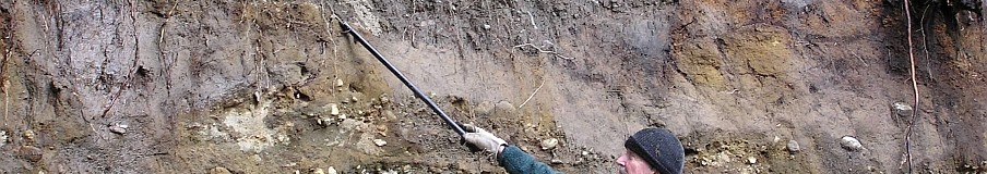
Justin serves as scale at the limestone outcrop on the Ridley Creek trail.
Take note of the next exposure of any significance, 1.9 miles along your way. The rocks are pretty unusual. The pale gray rock is one of the few places where limestone is exposed along a trail in the Baker area (Tabor and others, 2003). These are isolated lenses of the marine Chilliwack Group rocks, deposited on a sea floor during the Permian, Carboniferous, and Devonian Periods- between 415 and 250 million years ago. These rocks were accreted to the margin of North America when they were scraped off the subducting seafloor plate. I took a small piece home and dropped hydrochloric acid on it- it fizzed like crazy, indicating a chemical reaction that produced CO2. This is a sure-fire indication of carbonate rocks like limestone. One hundred feet beyond the outcrop is the first tantalizing view of the red Twin Sisters, and Park Butte to the east.

Closeup of gray limestone on the Ridley Creek Trail.

Volcanic and glacial strata in the West Fk of Pratt Creek.
Just beyond the limestone, the trail curves northward and begins to traverse toward Pratt Creek. The narrow but rock-strewn ‘West Fork’ is reached at 2.4 miles, elevation 4360′. Wander a few feet up the channel to see nice stratigraphy (photo at left). Several feet of gray till studded with boulders is at the base. This is Vashon till, from the last advance of the continental ice sheet. You may even find some round, very hard quartzite pebbles, picked up by the ice from streams draining into the interior of British Columbia off the west side of the Rockies. These provide more evidence for the thickness of the ice sheet here; you are 900 feet higher than the lonely granitic erratic you passed earlier. Similar granitic boulders are easy to spot in the drainage here, too. In the photo, the head of my ice ax rests on the contact between the till and a reddish deposit that contains rounded and angular blocks in a fine matrix. It sure looks like a lahar deposit to me. Right above is a pale, very fine-grained layer about an inch thick, sandwhiched between two black organic soil layers. The pale layer is ash from the collapse of the Crater Lake caldera in southern Oregon 7200 years ago. This layer is distinctive and can be easily recognized everywhere in the region by its thickness, pale color, and very fine-grained texture. It feels greasy when wet. It makes a very good time marker wherever you find it. The Ridley Creek lahar sits above the upper soill. There is also a layer of gray gritty ash from the last eruption at Mount Baker, the 5700-year ‘BA’ tephra. However, it is obscured in the tangle of roots and soil at the top of the stream bank, and pretty hard to pick out without a lot of practice.

Quartzite cobbles in the West Fk of Pratt Creek.

Mount Baker andesite (left) in the East Fk of Pratt Creek.
The trail crosses the wider ‘East Fork’ of Pratt Creek 0.3 miles further along. The rock outcrop on the left bank just below the trail crossing is the only exposure of a Mount Baker lava flow on this trail. The lavas on this southwest flank of Mount Baker are assigned to the ‘andesite of Mazama Park by Hildreth and others (2003); a sample of similar andesite lava frm further down Pratt Creek was dated to 43,000 years ago, among the oldest dated flows from Mount Baker, and probably representing the earliest stages of cone growth, when Baker was lower and less extensive than today.

Typical exposure of Ridely Creek lahar along the Ridley Creek trail. Not overly impressive, but distinctive.
At 3 mi descend to Ridley Creek’s wide bouldery course and cross. Not much of interest here unless you like a lot of andesite rubble in the stream bed. The route is across more open meadow from here on; much of the tread consists of the distinctive, pale, rubbly Ridley Creek lahar. The trail comes to signs for the Mazama cabin and camps at 3.3 miles. The three-sided cabin is near several tent platforms in a heathery meadow at 4430′, right below Park Butte and, to the east, Cathedral Crag, the remnant of a pre-Baker lava stack. (sorry, no photo but you can’t miss it.) Beyond the cabin, the trail heads toward the crag before switchbacking up talus below it. Cathedral Crag, 5187′, is a remnant of a single thick lava flow some 330,000 years old (Hildreth and others, 2003). It has been glaciated. The rock is basaltic andesite- on the cusp of the two compositions. Wes Hildreth (p. 752) speculates that the great thickness of this lava flow remnant argues for confinement in a paleovalley or marginal to a glacier, both now long-gone. While crossing the talus, look for a thin flake to smack open. The rock is rich in the mineral plagioclase (generally white or pale lath-like crystals) as well as some small, yellowish olivine. The rock’s age is contemporary with the much larger Black Buttes volcano to the north, but is compositionally distinct and likely erupted from a different, now-eroded, vent.

View west from below Cathedral Crag. Talus is from the crag; Twin Sisters in the distance.
The junction with the Park Butte Trail is reached 4 miles into your hike, at 4860′. There are a few tentsites and a pit toilet at the Cathedral Camp, to the left. Turn right to make the 600′, 3/4 mile ascent to Park Butte. Along the way, you have fine views north to Baker, and over Morovits Meadows toward the Railroad Grade and the south flank of Mount Baker. The lookout is perched on the summit of Park Butte- the rock is part the Yellow Aster gneiss complex, which is Jurassic to Cretaceous in age (Tabor and others, 2003). There is one rock that is different though. Half way up to the lookout the trail crosses a plateau with several small tarns. Wes Hildreth aptly named the andesite exposed here the ‘andesite of Tarn Plateau’. It is an orphan lava (no vent known) around 200,000 years old, much younger than Cathedral Crag lava, and compositionally quite different. The rock is rich in clinopyroxene, olivine and plagioclase. A great place for views across the little pools to Mount Baker.
Special thanks to Skagit Alpine Club for maintenance of the Park Butte Lookout.. You can stay in it, but it is first come first served.
References:
Hildreth, W., Fierstein, J., and Lanphere, M., 2003, Eruptive history and geochronology of the Mount Baker volcanic field, Washington: Geological Society of America Bulletin, v. 115, p. 729-764.
Scott, K.M., Tucker, D.S., and McGeehin, J. P., 2003, Holocene History of Mount Bakervolcano, North Cascades: XVI INQUA Congress Program with Abstracts, vol. 9, p. 51.
Tabor, R.W., Haugerud, R.A., Hildreth, W. and Brown, E.H., 2003, Geologic map of the Mount Baker 30- by 60 minute quadrangle, Washington:U.S. Geological Survey Map I-2660, scale 1:100,000.

Leave a comment