


By Dave Tucker originally posted in 2010. Access update in July , 2023

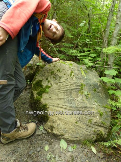
Eocene leaf fossil at Racehorse landslide fossil fields.
ACCESS
July 12, 2020. These directions have been completely updated today, after I was there on July 11. If you do this trip, please send reports of current conditions and also photos of your fun day to me. See the comments below to find the most recent access update. As of July 1, 2023, ‘Jack’ reported that “this blog gives accurate and easy to follow directions. The trail was recognizable, though overgrown. My car struggled to get to the parking spot, on a steep gravel road.”. DT
The Field Trip
The January 7, 2009 Racehorse Creek landslide is now overgrown with 10-15 foot alders and other bushes (see that field trip here). It is now more difficult to find plant fossils, but they are still there in the landslide rubble. The vegetation makes it more effort to spot them. The roads that were drivable in 2009 are now decommissioned; they are now foot trails. It is about a 1-mile walk to the landslide area. Don’t be concerned about taking specimens- there are so many and the really spectacular ones are too large to carry. The site is on DNR property; collecting plant fossils is permitted, but it is illegal to take any vertebrate fossils from the site (almost none have been found in the Chuckanut, in any case). Such finds would be extremely important to paleontologists. If you find any animal fossils, please photograph them and email me with photos. You can contact me at this cleverly disguised email address which only a human bean can read: dtchico at gmail dot com.
An imprint of a Sabalites sp.palm frond in a block of sandstone on the steep part of the trail.
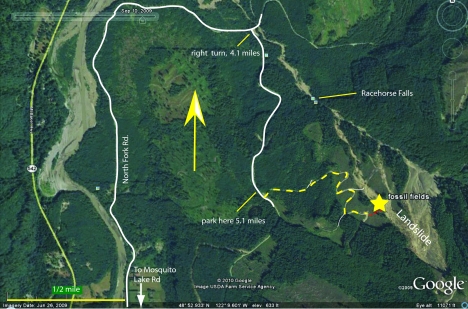
click map to enlarge. Red dash is the final footpath from the overgrown road to the fossil fields
Getting there: (Many thanks to readers who have sent updates over the years on the changing access conditions. Please continue to report.)
- Drive WA 542 [Mount Baker Highway] east from I-5 in Bellingham 17 miles to the junction with Mosquito Lake Road.
- Turn south (right). Cross the North Fork Nooksack River and turn left on North Fork Road. Set your trip meter to ‘0’ here. This paved road becomes gravel after 2.4 miles. In another half mile or so you enter lumpy terrain along the road. When the leaves are off the trees, you may see some car-sized boulders. The hummocky topography and boulders are the deposit of an older landslide that reached the Nooksack, dwarfing the 2009 slide. The hillsides above have slid multiple times since the end of the last glacial period, and the mountain itself is called ‘Slide Mountain’.
- After 4.1 miles, turn right at a major junction immediately before the bridge across Racehorse Creek (UTM E563652 N5414815). NOTE: UTM coordinates given are zone 10, NAD 27 datum to correspond with USGS topographic maps.
- DNR has posted that a Discover Pass is required for this logging road as it leaves the junction.Turn right on this gravel logging road, and head up the hill. In about 0.15 mile, you may note a trail head on the left marked by large rocks, with parking on the right. This side trip goes through the woods a couple of hundred yards to the rubble-choked course of Racehorse Creek. A short hike out this trail reveals effects of the January 2009 debris flows. Prior to the debris flows, Racehorse Creek was closely hemmed in with trees and brush. Vegetation is reclaiming the stream’s gravel bar, but it was swept clear by debris flows emanating from the 2009 landslide. You can walk up stream a few hundred yards to the lovely multi-tiered water fall. Believe it or not, kayakers have [intentionally] gone over the falls! But, we digress.
- Reach a junction at 5.1 miles (UTM E563745 N5413464) . This is pretty clearly marked with a red ’1′ painted on a tall tree on the right in a clump of woods. Park at the junction and walk up the spur to the left. [If you continue straight, you will reach a blue gate in another mile. If you do so, you know you missed the right place a mile back!]
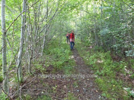
- The former road is blocked by a pile of rocks after a few hundred feet; scramble around this heap. Notice all the shells on the ground indicating correctly that a lot of shooting happens up here. Culverts have been removed so there are numerous ditches to cross from here on. This road is now quite overgrown as it switchbacks uphill. It isn’t very steep but climbing in and out of the ditches gets a bit old. The trail is well-used and it would be hard to go wrong. There is one spur to the left that’s quickly overgrowing and clearly less traveled than the correct trail. How fast do our roads get overgrown? Well, in 2010 we easily drove a big flatbed truck on this newly graded road during the ‘big bird’ fossil footprint helicopter rescue.
This was a drive-able road as late as 2015.
- In 0.8 miles you will note that the trail suddenly leaves the gravel of the former road and becomes an actual boot-beaten trail in the forest- at this point (UTM E564451 N5413353) look to the right and see that a dense stand of skinny alders obscuress the old road. This is where we parked the flatbed in 2010! The elevation is approximately 1450′.
- Walk the path through the forest. It’s obvious. In another 1/10th of a mile the alder trees suddenly become smaller- you have reached the margin of the 2009 landslide. Please consider taking pruners or a pruning saw with you to help keep this trail open. Please CUT BRANCHES next to the trunk, so sharp stubs don’t gouge other visitors.
- The trail veers right and up hill, and soon becomes quite steep. Some one left three ropes to help you get up what could be a pretty slippery slope- I advise extreme caution if you choose to use these ropes- you don’t know how safe they are ropes degrade over time. I suggest going all the way to the top of the slope, where you reach a minor ridge crest overlooking the main landslide deposit below you a short way on the other side.
The entire field trip is on Washington State Department of Natural Resources timber lands. Total driving time from Bellingham is less than an hour.

Racehorse landslide ferns- modern and ancient.
This ridge crest is still fairly open, and is covered with large blocks. Fossils may be found here, but you need to take your time and root about a bit to find them. Your predecessors may have left little stacks of fossils on logs for you to enjoy. You may have more success if you take the time to split the small rock slabs with a hammer and cold chisel.
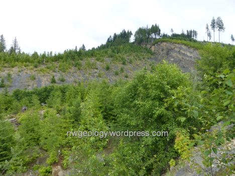
A view southwest from the ridge crest. The steep cliff is the scarp left by the 2009 landslide. It is about 200 yards away and nearly 100 feet high. Potential for rockfall at the base is quite high.
Keep your fossils indoors when you get back home. These rocks tend to decompose into uninteresting little chips if they are repeatedly exposed to wet and dry conditions. Feel free to send me photos via the email address above. Please put ‘Chuckanut Fossils’ in the subject line. Perhaps I can help identify your finds; if you find something that is new to the Chuckanut fossil inventory, your photo could end up being a useful addition to science. With your permission, I’ll post selected photos on the Chuckanut Fossils page (under construction) of this website.

Visiting Korean earth science teachers hunt for fossils in 2011. The site is overgrown now.
Learn more about the Chuckanut Formation, and the subtropical environment these fossil plants grew in, by going to this excerpt from a field guide by WWU paleontologist George Mustoe and colleagues.

Leaves of tree ferns (bottom left), Sassafras (center), and Taxodium (swamp cypress).

Took a trip up to the creek last week. Had good amount of sun, had great time. WHAT a great place to find interest in geology.
Does anyone know if the fossils at Racehorse Creek have ever been carbon dated.
Brad,
The Racehorse fossils are in the Chuckanut Formation, which is known to be around 50 million years old (Eocene). The rocks can not be dated using radocarbon, as they are far too old for this method. The carbon-14 isotope can only be used for organic material less than about 62,000 years. After that amount of radioactive decay, there isn’t enough C14 left to detect. The rocks have been dated using isotopes of potassium and thorium, as well as the zircon track method.
dt
Thank you for the info. I wasn’t aware that there was that limit to testing the carbon. I think that I found some pieces of chalcedony.Could there be some around maybe replacing wood? The pieces are well rounded.
Thank You
Brad
The chalcedony pebbles are more likely weathering out of the glacial till that overlies the Chuckanut in these hills, especially if the stones are more than an inch or so across. Pebbles in the Chuckanut tend to be pretty small, as the sediment was deposited a long way from source areas far to the east.
DT
Thank you. They were big and that explains the variety of rocks such as pieces of granite.
Another question:
I see what look like modern fauna forms. Maple,palm,fern. The climate at the time is said to have been tropic(or sub-tropic). I am wondering if this area was physically where it is now In Washington State. Was the climate tropic because it was physically near the equator?
Brad
Yes Brad, these rocks were deposited at our current latitude. The fossils do reflect a warmer climate. Analysis of leaf design by Mustoe and others show that subtropical conditions pertained, with a mean annual temp of 15 C, much warmer than here today. Good refs for this work are listed at the end of this site:
http://books.google.com/books?id=F1Sx3i2CZyUC&pg=PT128&lpg=PT128&dq=doi:+10.1130/2007.fl+d009%2806%29&source=bl&ots=BU39lBQQdj&sig=gF_r-MkhfVr1KUmIMP3ue1ialZ8&hl=en&ei=dZgtS4b6LZD-sgPn0vnGBA&sa=X&oi=book_result&ct=result&resnum=2&ved=0CAoQ6AEwAQ#v=onepage&q=doi%3A%2010.1130%2F2007.fl%20d009%2806%29&f=false
Also, visit my Chuckanut intro page here:
dt
Just hit it today, easy to find. Didn’t get too far up the trail with my son (3 years old) but still came home with a pile of great fossils. Even what looks like petrified wood!
Does anyone know whether the gravel road (say, from the “right turn, 5.1 miles” marker on the map and on up the hill) was laid using rock taken from the immediate hillsides or hauled in from elsewhere? The reason I ask is the abundance of well-rounded river-like rocks, including some spectacular agates, at whose origin I’d love to go rockhounding. Thanks!
Daniel,
I’m going to guess that the rounded rock was hauled in from a quarry. I’m unaware of any quarries in Racehorse area. There is one down in the valley- if you go straight and cross the bridge over Racehorse Creek, you’ll eventually come to a large gravel quarry, less than 2 miles from the bridge. Stay left all junctions. I think it is an active quarry, so access may be a problem, and no guarantees it is the source of the road rock. You can go out on the Noksack gravel bars at many places and look at, and collect, all the river rock you can carry.
Dave
Just got back. The road was in good condition and my small Honda made it all the way up, despite the misty rain. The trail was clear but for a few small fallen trees. The area is much more grown up now than in the pictures. I would definitely take some pruners or a large blade next time. Lots of giant chunks of shale all around. It would be worthwhile to bring a shovel and quality chisel to explore some of the large chunks that are shallowly emersed in the loose soil. There are enormous finds just laying around above the soil, I can only imagine the monster fossils that lay beneath!
As of February 9, 2016:
Gates are now open and the approach roads in good shape easily passable in any vehicle with more than an inch or two of road clearance (i.e., not suitable for your Maserati). North Fork road is potholed but mostly mud-free to the junction before the Racehorse Creek bridge; the spur leading uphill to the right is also solid, absent the potholes. 100 yds. after taking the left across from the obvious ‘1’ painted on a tree the road is thoroughly blocked–deep ditch, large boulders, felled trees. Parking for ten cars or so.
20 minute leisurely walk up the rest of that logging road, clambering in and out of a dozen fresh trenches, no more than a week or two old. Obvious footpath to the left next to a pile of stumps and slash (described above as a “high pile of logs”); a few survey flags in yellow and blue. A machete would be handy, and probably more so in the spring.
Thanks for the website and all the information!
Visited 7-23-2016
The hike in is exhausting. they put 17 large ditches and a road block in the road before you leave the road for the 100yd hike. Those guys must be paid per ditch. I brought by bicycle but it was no help with all the ditches. The area has gown in allot compared to these photos. Fossils are plentiful and fun fun fun to find. The view from the boulders above the dead tree landmark is worth the hike up(follow main trail past big dead tree).
What a great place! We went to check it out last weekend, and the above directions were well written. The road is blocked at the last fork to the left. It’s about a 1.5 mile hike running thru a bunch of culverts, but not too bad. The thimble berries, raspberries, black raspberries, black berries, and currants along the way made it worth while. The only challenge was finding the trail at completing the 3rd switchback into the 4th on the above map. Look to the ground; someone was nice enough to put an arrow in rocks. Also look for the pink tags tied to the trees. Again thank you to the person who marked the way. The first 100 yards off the road was a little overgrown, but our machete hacked through it nicely. Head up the ridge, and you will find some really nice specimens as well as an awesome view.
I live in Ellensburg and I’ve been trying to find the Chuckanut layer in the mountains are here but cannot. I went to Liberty yesterday and looked aton Blewett pass and the closed old road as well. Please advise.
Susan,
The Chuckanut-related rocks on the east side of the mountains is called the Swauk Formation. There is a map of the distribution of all Chuckanut and related sedimentary formations here: https://en.wikipedia.org/wiki/Chuckanut_Formation#/media/File:Chuckanut_outcrops.png
The Wikipedia article on the Chuckanut Formation https://en.wikipedia.org/wiki/Chuckanut_Formation gives a pretty good summary of the realitonship of these related rocks. Dave
Took the hike to the site 09 Aug 2018…very hot about 90F with no wind (don’t recommend in hot weather) Trail was well maintained…no major issues. Took 10yr old son and 17 yr old. 10yr old loves fossils…with a little digging found lots of fossils. We did not want to take chance with kids to ridge…very steep and loose. 10yr old lost his rock hammer so if you find one up there please let me know. We had to leave because we ran low on water. We also went on hike through creek bed and found three toed fossilized footprint but rock to big to remove…took picture…keeping location secret. We hope to go again…it was alot of fun !!!! Thank you for the instructions they worked great.
Carl
My 6yo daughter (Katie) and I went up last week. The directions are good. She’s very timid but was able to negotiate the ditches by holding my hand in most cases. We were able to observe a large garter snake and found plenty of fossils. We mostly took pictures of what we found but took three small fragments. One was a fern. Another was what resembled a cottonwood leaf and the final leaf was similar to a rhododendron. Katie decided to be our photographer for this expedition.
Something that might be handy though not necessary is about 50′ feet of 0.5 inch braided rope. One section of the blazed trail after the young, dense forest was pretty steep and Katie would have had an easier time if she had a rope to pull herself up.
Did the trip with my 4 year old last weekend. We had a great time and found tons of fossils. The trail is currently marked with a lot of pink and orange flagging tape from the start of the logging road hike all the way to the fossil area. The ditches on the walk are numerous and can be steep so my 4 year old needed a hand going down and up some of them. The google earth maps on the site were still helpful though, particularly in mapping progress up the logging road walk/hike.
Thank you AP. Much obliged.
Made our first trip out to the fossil fields today. The trail is clear and still well marked. With a 4 and 6 year old we didn’t make it past the steep rope section, but found plenty of fossils in the area just below it. Thanks for the detailed writeup with directions!
Took our family 1/21/21 and these directions were spot on. Trail was pretty clear and easy access. We found all our fossils at the first little creek we came to, so many different types. Our trip did not disappoint and now we will try to identify them all. Thank you for this lovely information!
I visited the landslide on 05/02/21, and the directions were spot on. The trail was pretty clear and it was relatively easy to reach the steep rope area. The rope was present, and was incredibly helpful; we managed to reach the top of the landslide safely. The steep rope section is incredibly steep, so be careful if you would like to reach the top of the landslide. We ran into George Mustoe at the top – and he walked us through some of the footprints / trace fossils that can be found around the landslide. Thank you so much for this wonderful information!
Hey Zachary, thanks for the update! Glad you had a good time at the fossil fields. Dave Tucker
If you want to collect fossils but cannot walk a mile, there is an option right beside the road. Follow the directions to the big number “1” parking area, but don’t stop there. Continue along the road a few hundred yards until you get to the clear cut on the left. There is a place to park next to the brush pile on the right. You will find fossils within 10 feet of the road on the uphill side. This shelf of material continues for 50 feet or more along the road. You will need a hammer and chisel. A paleopick and a rock bar could be helpful. A couple of young guys to do the work would be best. I have photographed several full sized palm fronds along this road over the last 6 years or so. [This post slightly edited by DT].
We did the full climb/hike yesterday and it was a great experience (with my grandson). For those who don’t want to do the long hike, we found some pretty nice fossils also in the rocks along Racehorse Creek eg. at the bridge). Look for those sedimentary rocks with natural cleavage lines or fissures. Try to separate them at the fissure and you will find fossils.
As of May 15th, 2021, the red gate is now blue. The paint looked pretty fresh. Otherwise, wonderful time!
Trail was in good condition, nice length for a mid-winter hike with minimal snow. Kids found some fun small fossils, though next time we’ll plan to head out earlier for more daylight for searching.
Went up there a couple days ago. The trail was in good condition but the steep part at the end was super slippery. Really cool place
This blog gives accurate and easy to follow directions. The trail was recognizable, though overgrown. My car struggled to get to the parking spot, on a steep gravel road.
The updated record of the Racehorse landslide fossil fields by Dave Tucker, published in July 2023, demonstrates his commitment to and love of paleontology. Anyone interested in the region’s geological history will find his in-depth observations and insights regarding these exceptional fossil finds to be priceless. An essential book for professional geologists as well as amateur fans.
Insightful perspective! Fossil plants aren’t just relics; they are storytellers of Earth’s past. Your blog beautifully captures the narrative embedded in these botanical fossils, reinforcing the need for responsible environmental practices for a sustainable future.
Hi everyone! My name is Charlie, born and raised Bellingham. Been interested in geology my entire life, took a couple classes while in school, totally hooked.
I have been collecting agates my entire life, i have thousands of them. 1 thing in common, they all came from the beach. I am really trying to get after some of the big ones, the nodes, the thunder eggs. I learned of place named Walker Valley where all of this is possible. Even amethyst i hear?
Anyway my question to the expert who made this page “DT” or to any other rockhounds that may be reading this, is RaceHorse Creek a place to rockhound, or is it mainly fossils. I understand this area is sandstone, and that agates form in the air pockets of hardened lava. So does that mean Racehorse Creek wouldn’t contain any metamorphic material? I havent been up there yet, thought i would ask you guys first!!!
Also, if anyone has any suggestions for river agates in Whatcom/Skagit County, i would greatly appreciate it!!!
Thank you so much!!!
-Charlie Bailey, Bellingham
My email:
charliebailey86@yahoo.com
Nope, Charlie, Racehorse is not a place to rockhound. Entirely sandstone/shale. Best place for agates is the beaches- everything is a glacial erratic, and lots of those carried down from Canadian interior. Geology all wrong around western WA for any agate outcrops. I’m not a rockhound, but a geologist and pretty familiar with the region.
Thanks magmatist. Have you heard of Walker Valley though? It’s located east of Mount Vernon,WA, and i guess it’s loaded with a bit of everything.
Yes I have been there, but as I’m not a collector I haven’t looked at mineral crystals.
Walker Valley has a variety of material from agate to jade to amethyst to geodes. It has been heavily worked over the years but new spots are being discovered. Hook up with the washington State Mineral Council for information and new dig sites. They have the claim on the rock collecting area.