


Fidalgo Island geology. Red line marks the route, and stops are numbered. Click to enlarge.
Fidalgo Island boasts its very own ophiolite sequence. Ophiolite refers to the sequence of rocks that make up a section of the oceanic crust. (The term refers to the assemblage of certain rocks, not to a particular type of rock. A fairly complete section through an ophiolite, from mantle to sea floor, is uncommon and should be on the ‘bucket list’ for any geophile. The Fidalgo ophiolite, according to the interpretation of WWU geologist Ned Brown, includes rocks associated with a Jurassic volcanic arc that grew above the seafloor. The ophiolite is similar in age and appearance to the California Coast Range ophiolite. Were they once conterminous, now separated by strike-slip faulting that dragged one north- or the other south? That has yet to be answered. Earlier I posted a field guide to Part I of the Fidalgo ophiolite when we visited the lowest rock in the sequence, serpentinite from the top-most layer of the mantle at Washington Park. Go to the ‘Geology Guide’ portion of that field trip page for a quick review of the ophiolite sequence. Now we’ll visit the upper part of the Fidalgo ophiolite, the rocks that make up the crust, so consider doing these trips in sequence on a nice sunny day so you’ll have grand views from the top of Mount Erie. Much of this field trip is based on descriptions by Brown and others (2007). See references at the end.

Section through the Fidalgo ophiolite. (From Brown and others, 1979).
Part II visits sites that are sequentially higher in the ophiolite complex. The ophiolite sequence is not complete: there are faults that interfere with a perfect ordering. Take a look at the geologic map. The ophiolite units are shown in colors. The whole sequence is tipped on its side during accretion and faulting, so the deepest portion, the serpentinite (blue) is to the west, and the uppermost, the ocean floor lava flows and sedimentary rocks, are toward the east, with the intracrustal intrusives (purple) in the middle. Kinda cool, isn’t it?
A geology field trip will visit some of these rocks on April 12th, 2014. It is a a fundraiser for Mount Baker Volcano Research Center’s scholarship fund. Go here to learn how to sign up.

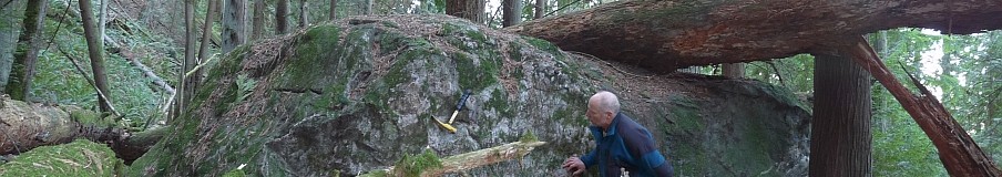
Gabbro at Stop 1. Note the pale vertical dikes near the yellow hammer. Click any image to enlarge.
Getting there: This self-guided geology field trip picks up where Part 1 ended, at Washington Park. The park is at the west tip of Fidalgo Island, at the end of the road that runs from Anacortes to the San Juan Island ferry terminal. Use ‘Getting there’ in Part 1 for those directions. Leave Washington Park and head east on Sunset Drive. It is 0.7 mile to Anaco Beach Drive, where you head south (right) to Stop 1. In 1.3 miles, just after sweeping around a curve to the left and then right, and opposite Marine Heights Way, is the first stop at Osprey Lane. Turn into the lane and immediately park near the rock outcrop. There may be construction here so access to this outcrop is tenuous and may eventually be inaccessible.

Gabbro at Stop 1. The dark mineral crystals are pyroxene, the white ones are plagioclase feldspar.
Stop 1– Intrusive gabbro of the deep crust. (Sometimes called ‘dolerite’; 48°29’9.43″ N 122°39’47.17″ W via Google Earth). Somewhere between Washington Park and here you have crossed the unexposed (dang it) boundary between the uppermost mantle and the deepest rocks in the crustal part of the ophiolite. At this stop the rock is salt-and-pepper speckled gabbro, an intrusive rock that, if it had reached the surface and erupted, would be basalt. Basaltic magma rising out of the mantle stalled deep in the crust. The gabbro is a cumulate, consisting of the minerals that were left behind in a crystalline mush as the less dense liquid fraction of the melt continued upward; the gabbro cooled slowly at It is quite unusual to see gabbro anywhere in the region. Weathering and alteration have discolored many of the surfaces, so find the freshest little bit you can and get out your ever-ready hand lens. The white crystals are Ca-enriched plagioclase, and the dark ones are the mafic pyroxene mineral augite, also high in calcium. A few pale vertical dikes a few cm wide cut the rock. I’m not sure when these dikelets intruded the gabbro, and confess I didn’t look at them closely (it was nearly dark when I was there). They may be related to the plagiogranite we will see at Mount Erie. If anyone can make any further observations on these fine-grained dikes, please use the ‘reply’ box below.

Mount Erie from the south.
Now head for Mount Erie and intrusive rocks much higher in the crust. Directions are circuitous, so listen up! Continue south on Marine Drive (name change from Anaco Beach Drive). About 0.6 mile beyond Stop 1 you’ll pass some high roadcuts on the east side but I didn’t stop to examine them. According to the geologic map this is still gabbro, but it wouldn’t hurt to take a look if you can find a place to pull over, and let us know what you find out. There may be some nice exposures along this big cliff. You’ll probably need a hammer to get a fresh surface.
1.6 miles from Stop 1, turn left on Havekost Road toward Anacortes.Pass Lakeside Industries quarry described in Brown and others (2007), but it is closed to the public. In any case, according to Eric Cheney, quarrying has revealed different exposures from those described in Brown and others.
1.7 mi- turn right on 41st St,
0.5 mi- turn right on H Ave. which becomes Heart Lake Road.
1.4 mi- turn right at Ray Auld Dr and go 1.7 miles to the top of Mount Erie.

Diorite at Mount Erie. Green is algae.
Stop 2– Mount Erie diorite. Please, do not use hammers in this city park. From the parking lot, find your way out to the big views on the bare summit knobs. On really fine days, you can see south to Mount Rainier. The rock here consists of diorite, a less mafic intrusive rock than the gabbro we saw at Stop 1. These rocks are interpreted to represent the cooled interior of magma chambers within a chain of volcanoes rising above an oceanic subduction zone. The diorites could be the more felsic magma that rose above the gabbro represented at Stop 1. (Diorite that erupts is called andesite.) Felsic (i.e. with elevated silica, vs. mafic rocks like gabbro/basalt) rocks like these that are found in oceanic crust are generically referred to as ‘plagiogranite’, which is a suite of intrusive rocks that include the granite-like rocks diorite, trondhjemite, and tonalite that are constituents of oceanic crust; plagiogranites are not common. A recent whole-rock geochemical analysis of a plagiogranite sample from Mount Erie gave 70% SiO2 (Grimes and others, 2013). A uranium-lead radiometric date from zircon crystals in the diorite gave 167 ± 5 Ma (million years).

Mount Erie diorite. This rock has a higher proportion of minerals enriched in silica, especially plagioclase feldspar.
Once you are done admiring the view head back down the road. Turn left on Heart Lake Road. Mileage is cumulative from this junction
1.3 miles- turn right onto Rosario Road at the corner store.
2.1 miles- veer left and stay on Rosario Road.
3.7- turn left on Sharpe Road. In 1/4 mile, Sharpe Road turns sharp left, but you continue straight (east) on Ginnett Road. Pass Mud Lake on the left and continue to the end another 3/4 to a gated trail. Turn around and go back west a couple hundred yards and find a place to park just west of the mailbox for #4579. Don’t park in the turnaround.

Sedimentary breccia north of the cement slab at Stop 3.
Stop 3- Ocean floor sedimentary rocks and basaltic lava. No hammers in Deception Pass State Park. Walk past the gate on the old road 250 yards to a cement slab at the brink of a lichen-draped rock cliff (sometimes called ‘Red Rock Quarry’). The walls of the steep cliffs south of the slab are greenstone, or slightly metamorphosed lava; you can scramble down to look at the rocks, but only a special kind of geologist could really love ’em. Rocks in the 3-foot-high bank north of the slab are sedimentary breccia, and worth taking a look at. I think the clasts (rock fragments) are volcanic that probably cascaded off seafloor lava flows. Again, the exposures are not exactly world-class, but fairly unique for the Fidalgo ophiolite. Back at the car, the dark rock in a shallow alcove at this pullout is black argillite (with brown oxidized fracture faces). There is some red argillite at the mailbox for #4579. Argillite is only barely metamorphosed beyond the original fine-grained mudstone that originated as sea floor sediments intermingled with the lava flows. Microscopic radiolarian fossils in similar argillite elsewhere on Fidalgo Island are around 150 Ma, younger than the plagiogranite.

Very fine grained argillite near the parking area for Stop 3.

Greenstone (meta andesite) at Stop 3.
Backtrack to Rosario Road, and turn left. This will take you to Highway 20 in 1.9 miles. Turn right and head toward the Deception Pass Bridge. In another 1/2 mile, just before the bridge pull over in the paved roadside pullout on the right.

Sedimentary beds at Stop 4.
Stop 4– The cliff across the road is tentatively assigned to the top of the ophiolite sequence. Spend some time walking along the face looking at details. The rocks are distinctly bedded, which dip as steeply as 60 30 degrees down and into the rock face. Most of the rock is graywacke with some argillite and a few chert beds. Graywacke is a poorly-sorted sandstone that is well-indurated. Look closely and you can see angular rock fragments within a fine-grained matrix. The chert is from the siliceous tests, or shells, of diatoms. Thousands of people drive by; I have only once seen anyone looking at them, though the rock cliff is among the most impressive on the island. If you see someone, say hello- they are likely there because they, like you, visited this webpage.

A single bed of chert helps define the tilted layers at Stop 4. The beds dip into the cliff.
That’s it. There’s plenty more to see in the area, including the deformed pillow basalts and ribbon chert at nearby Rosario Head. These are not part of the Fidalgo ophiolite. They have chemistry consistent with a mid-ocean spreading center, rather than an oceanic volcanic arc lying above a subduction zone. I’ll write about them another time.
Brown, E.H., Bradshaw, J.Y., Mustoe, G.E., 1979. Plagiogranite and keratophyre in ophiolite on Fidalgo Island, Washington. Geological Society of America Bulletin 90, 493–507.
Brown, E. H., Housen, B. A., and Schermer, E. R., 2007, Tectonic evolution of the San Juan Islands thrust system, Washington: in Stelling, P, and Tucker, D. S., eds., Floods Faults and Fire: Geological Field Trips in Washington State and Southwest British Columbia: Geological Society of America Field Guide 9, p. 143-177.
Grimes, C.B., Ushikubo, T., and Kozdon, R., and Valley, J. W., 2013, Perspectives on the origin of plagiogranite in ophiolites from oxygen isotopes in zircon. Lithos, v. 179, p. 48-66
http://www.geology.wisc.edu/~wiscsims/pdfs/Grimes_LITHOS2013.pdf

Hi! Thanks for your great article. I love learning about the geology of Washington. Have you written anymore about the deformed pillow basalts and ribbon chert at Rosario Head? I am especially interested in the pillow basalt. Is that from the Juan de Fuca mid-ocean ridge? Is it in the subduction trench? Do you know the age of it? (I am a science teacher and am writing a place-based plate tectonics curriculum and this would be super helpful info for the curriculum!). Thanks so much.
Hydrogen from ophiolites seems more economical than so-called blue and green hydrogen. https://www.science.org/content/article/gusher-gas-deep-mine-stokes-interest-natural-hydrogen?utm_source=sfmc&utm_medium=email&utm_content=alert&utm_campaign=DailyLatestNews&et_rid=220764734&et_cid=5094239