By Dave Tucker
January 31, 2014

Serpentinite at the foot of the stairs has been planed level by Pleistocene ice.Note the black rip rap boulders at right. Click to enlarge any image.
A bit of the earth’s mantle is exposed at Anacortes’ Washington Park. The rock is the metamorphic rock serpentinite, and was originally in the upper portion of the earth’s mantle below oceanic crust- somewhere. Exposures are found along the dramatic rocky shore and on bare knobs above the coastal cliffs. The parent rocks (before metamorphism) were dunite and pyroxenite. These are ultramafic (meaning low silica, high iron and magnesium) igneous rocks that form only in the mantle. A single essential outcrop is highlighted in this quick self-guided field trip, although longer strolls can be made along the sea cliffs and grassy rock benches. This description explains what ‘ophiolite’ is.
This field trip can be paired with the next installment, Fidalgo Ophiolite Part 2, which will be a trip to Mount Erie and other places south of Anacortes. However, Part 1 is long enough as is. Until I get Part 2 published, pick a nice sunny day and enjoy the scenery and rocks at Washington Park.

Washington park map. The trails near Juniper Point in the SW corner hae great views and fine rock exposures. Click to enlarge.
Getting there: Washington Park occupies a point of land on the west tip of Fidalgo Island, just west of the San Juan Island ferry terminal in Anacortes. Follow signs through Anacortes toward the ferry terminal, but pass the entrance to the ferry landing and continue west on Sunset Drive 3/4 mile to the large parking lot in Washington Park.
The paved road becomes a 2.2 mile one-way loop through the park, well worth the drive, but even better on a bicycle, though there are some ups and downs. This loop is open at 6 AM for pedestrians and 10 for autos. It is only 1/2 mile from the parking lot to the principal exposures described here, so you may prefer to ditch the car at the parking lot and enjoy the stroll along the road or the parallel trail. There is more information about this very scenic city park at the Washington Park website. There are hiking trails (se the map at left) and the views over the saltchuck are great. From the parking area, continue along the loop road for 1/2 mile. Immediately beyond the large grassy slope at Green Point watch for a small parking area on the right ( and a larger space in the woods to the left). A stairway descends to the shore line rock outcrops from this parking area. This is between points 4 and 5 on the map at left. There are outhouses across the road from the stairs. There is a geologic interpretive sign on the lawn at Green Point. This is a city park- NO HAMMERS, PLEASE!!
Geology Guide:

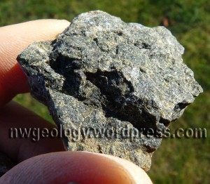
Detail of a piece of dunite from Washington Park. Olivine crystals do not have smooth crystal faces, so individual grains are not well defined. The minerals in this siample are around 5mm across.
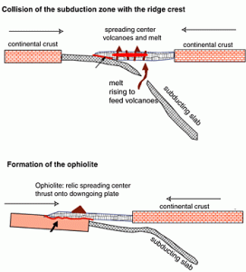
At the foot of the short stairway is a wave-worn bench of rough reddish brown rock. This is serpentinite, considered to be the basal portion of the Fidalgo ophiolite. ‘Ophiolite’ refers to a section through oceanic crust that includes some portion of the underlying mantle, often but not always at a mid-ocean ridge, or spreading center. Ophiolite is not a particular type of rock, but a particular sequence of rocks. The classic sequence is shown in the diagram below.

A model for obduction. The thin red line represents the slice of mantle rock carried along as the ‘sole’ of the obducted ocean slab.
Peridotite and dunite are the principal rocks found in the upper mantle. Dunite consists almost entirely of the magnesium rich mineral olivine, while peridotite has some iron-bearing pyroxene along with the olivine. The term ‘peridotite’ refers to the olivine – peridot is gemstone-quality olivine. Because mantle rock chemistry is exceedingly poor in silica (< 45%) and ‘ultra’ rich in magnesium and iron, they belong to the ‘ultramafic’ class of igneous rocks. (‘Mafic’ refers to ‘magnesium+ferric’. Mafic rocks, such as basalt and gabbro, are merely ‘low’ in silica, 46-52%). Ophiolites are believed to be thrust onto the crust of island arcs or continents during ‘obduction’, which shoves the thin slab of ocean crust and some of the mantle over and onto the thin wedge at the leading edge of another portion of crust, rather than carrying it into the mantle by subduction. The ophiolite is often chopped up by faulting during obduction, so intact cross sections are uncommon. The Fidalgo ophiolite includes most of the layers shown in the diagram above (see the next figure). The cumulate gabbro (residual minerals left in a magma chamber within the crust as magma continues to move upward via dikes toward the surface) is exposed south of Washington Park on private property, the dikes and flows are on Mount Erie, and the sedimentary rocks are best exposed in a (private quarry), but also along the road up Mount Erie and an old (accessible) quarry to the south. I will provide a description for these other locations on a coming field trip. If you read the geologic literature about the Fidalgo or other ophiolites, you will likely come across the term ‘ultramafic tectonite’, a catchall term for ultramafic rocks that have been deformed in the solid state. However, there is little basalt, and none with a mid-ocean ridge chemical signature, and the igneous rocks are preponderantly andesite and dacite. These argue that the Fidalgo ophiolite represents a section through a volcanic island arc, not the thin crust of abyssal plain.

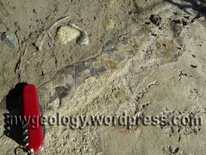
The ‘snake-skin’ texture of serpentinite lends its name to ‘ophiolite’. This is a nice example near the foot of the stairs.
Serpentinite is rock rich in the mineral serpentine, derived from olivine soaked in hot water to hydrate the chemical structure: MgSiO + H2O = Mg(OH)(SiO). The serpentinite is actually responsible for the origin of the ophiolite term: it means ‘snake rock’ (Greek ophios + lithos), a reference to the scaly appearance of fresh serpentinite exposures. Serpentinite is derived from both dunite and peridotite.
The rock in the shoreline ledge is a mix of both dunite and peridotite. Peridotite predominates; rust brown rock at the foot of the stairs reflects interaction of water with the pyroxene in the peridotite. Look for some very pale greenish layers within the serpentinite; the largest I saw is around 30 cm thick . These are dunite, essentially pyroxene-free and therefore not rusty in appearance. Also keep an eye out for the ‘snake-skin’. This is best seen on vertical, relatively freshly broken faces. The rock is highly fractured from expansion as it was uplifted from great depths to the surface.
The rock bench features spectacular glacial erosion. The rock is generally rough as the coarsest sandpaper. However, glacial erosion planed this exposure during repeated Pleistocene glaciations. For spectacular evidence of the polishing effect of the sediment carried at the base of a glacier, you have to put your nose right up to the rock. Till overlies the serpentinite at the back of the cliff. Wave erosion is stripping this cover away; that’s why the dark riprock boulders have been placed at the base of the till. Get down on your hands and knees where the till rests on the serpentinite. You should be able to find places where there is mirror-smooth serpentinite scratched with glacial striae. This thin veneer of polished rock rapidly weathers away, and may only be present for a few centimeters seaward of the till overburden. Stroll south along the gravel West Beach. Clay and sand from the till have been washed away by the waves, leaving a lag deposit of cobbles eroded out of the till. Walk to the south end of the little pocket beach. More serpentinite forms a low ledge. a deep groove several feet wide has been scoured into the rock.

The trail above Juniper Point reveals glaciated serpentinite. Weathering produces distinctive red soils, the weathering product of magnesium and other minerals common to mantle rocks: chromium, nickel, and iron.
Where on Earth did this rock come from? The Fidalgo rocks are dated to the mid-Jurassic. The supercontinent Pangea began breaking up after these rocks were formed. They were part of a long-gone volcanic island chain out in the vast Panthallasic Ocean separating the west and east coasts of the northern portion of Pangea. The generally westward movement of North America gobbled up this ocean chain. However, radiolarian fossils in the uppermost portion of the ophiolite sequence are equatorial. So, the islands were at one time far south of its present latitude. Did the island chain move northward through the proto-Pacific prior to collision with North America somewhere near their present latitude? Or did they collide with the continent far to the south and then move northward along the continental margin in a San Andreas-style strike slip fault? The San Juans consist of a mash-up of different rocks of different ages and different origins, all thrust together and stacked up. The Fidalgo ophiolite is part of this train wreck. We won’t get into that on this field trip.
REFERENCES:
Brown, E. H., 1977, Ophiolite on Fidalgo Island, Washington: in Coleman, R.G., and Irwin, W.P., eds, North American Ophiolites: Oregon Department of Geology and Mineral Industries, Bulletin 95, p. 67-93
Brown, E. H., Bradshaw, J. Y., and Mustoe, G. E., 1979, Plagiogranite and keratophyre in the ophiolite on Fidalgo Island, Washington: Geological Society of America Bulletin, v. 90, p. 493-507.
Brown, E. H., Housen, B. A., and Schermer, E. R., 2007, Tectonic evolution of the San Juan Islands thrust system, Washington: in Stelling, P, and Tucker, D. S., eds., Floods Faults and Fire: Geological Field Trips in Washington State and Southwest British Columbia: Geological Society of America Field Guide 9, p. 143-177.


For anyone reading this account and noted both the caution THIS IS A CITY PARK. NO HAMMERS PLEASE! while also seeing the image with his yellow HAMMER in the picture, please rest assured that geologists use whatever is handy to show scale in pictures. He wouldn’t be bashing on rocks. His hammer is always handy and you will see it in many of his pictures for scale. I often use my ever-present coffee mug.
Thank you for catching this and commenting, Doug. I always carry a hammer, and use it for scale nearly as much as I use it to smash rocks. My hammer can be seen from a distance in photographs, unlike car keys or coins. However, in some protected places, especially National Parks, I leave my hammer in my car so as not to set an (inadvertent) bad example or to seem to be flouting the entirely reasonable laws.
Dave
I went to see this area last Friday; stormy with wind and rain; still impressive. Will return in better weather. Then that evening went to WWU to see the geology exhibits. Interesting and well done. Thanks.
Thanks……good read. Al Vogel
[…] https://nwgeology.wordpress.com/the-fieldtrips/fidalgo-ophiolite-part-1-a-bit-of-the-mantle-at-washi… […]