

By Dave Tucker March 23, 2010; thanks to John Bremer for updated access information (February, 2012).

K. Kemplin nonchalantly examines the phyllite outcrop at the end of the field trip. Click to enlarge any photo.
This trip examines an exposure of the metamorphic rock phyllite and discusses how the rock got its characteristic flattened and folded appearance- known as ‘ foliation’. Phyllite is not hard to find in the western foothills of Whatcom and Skagit counties. However, this particular place has well exposed and relatively large cliffs (30 feet high), is an easy stroll, and has views up the South Fork Nooksack River. On a clear day, it is even sunny! Thanks to Carolyn McGlothlin and Keith Kemplin of Bellingham for finding and investigating the outcrops and the route.
The phyllite exposed here was mapped as Darrington Phyllite of the Shuksan Metamorphic Suite (Brown and others, 1986; Brown 1987). We visited related rocks of this suite further west on Blanchard Mountain at the Oyster Dome and stilpnomelane mineral site field trips. There is a large exposure of phyllite mentioned in the stilpnomelane field trip, right beside the road, but it is not easy to observe up close, nor as fun to visit as this place. The phyllite in the South Fork Nooksack has since been mapped as ‘Semischist and phyllite of Mount Josephine’ (Dragovich and many others, 2002; Tabor and others, 2003). Rowland Tabor correlates the Mount Josephine phyllite with the Darrington Phyllite of the Easton Metamorphic Suite (Tabor and others, 2003). The Josephine and Darrington phyllites differ in that the Darrington version, generally found south of the Skagit, is marginally finer-grained and has more phyllitic crenulations, or kink bands, than the Mount Josephine variety. These are metamorphic foliations resembling accordion folds. The Josephine phyllite is decidedly smoother on flat foliation planes. You wanna split hairs? Knock yourself out.

Cross-cutting deformation of the phyllite resembles the end of a sheared log.
Getting there: The outcrops are on the extreme west margin of the Cavanaugh Creek 7.5′ topographic sheet; the entire road and virtually all the walking approach shows on the Acme map, although the road east of the Skookum Creek bridge is marked as a ‘jeep trail’- definitely not the case for the first 0.5 miles. A map is not necessary, however, as the route is obvious.
Find your own way to the intersection of WA State Route 9 and Saxon Road- this is 2.5 miles south of Acme in Whatcom County, along State Route 9 between Acme and Wickersham in the subtle drainage divide between the north-flowing South Fork Nooksack and south-flowing Samish rivers. Take Highway 9 north from the east edge of Sedro Woolley, or south from the Mount Baker Highway. Or get there by going east from Alger by way of Cain Lake Road and the south end of Lake Whatcom on the Park Road. From Highway 9, go east on the Saxon Road, along the South Fork Nooksack. In 3.2 miles come to the Skookum Creek Hatchery, then curve right and park on the wide shoulder just before the birdge over Skookum Creek at 3.5 miles. This is the end of the pavement. If the gate is open (it generally is on weekdays). walk 0.5 mile and take the right fork at ta junction- the road left is overgrown.

And here is the fibrous end of a mangled log, taken nearby.
at UTM E563900, N5390670 (NAD 27 coordinate system, as always on this website, to conform to USGS map grids. See the UTM primer for more on this). Walk the easy track along the old road bed. There are several phyllite exposures to examine. This old road continues further, but the best outcrops are at this location.

Relict bedding is sometimes preserved in the phyllite.
The Field Trip: Foliation in Phyllite
Amble along the old road heading up the valley. This is logging country, which makes for nice rock exposures with light to see the rocks. The track traverses steep slopes a few hundred feet above marshy terraces along the river. You will shortly begin to see low cliffy exposures of phyllite, the dark gray shiny rock. Note that some of the rock faces are cut by vertical fractures. In some places, the rock appears to be offset along these fractures, though this is probably due to erosion facilitated by the vertical cracks or ‘joints’ (more later) and the horizontally fractured rock, rather than fault movement. I didn’t see any slickensides or other telltale evidence of fault movement. Probably the best exposure is about 0.5 mile (0.8 km) along the track, UTM E564790 N5890050; that is as far as I went. The rock there is splintered-looking and curvy, resembling the woody grain of the broken end of a log. What accounts for this appearance?
This is a metamorphic rock. The interpretation is that muddy sediment (mostly clay minerals and microscopic mica grains) was washed onto the floor of the ancient Pacific Ocean around 163 million years ago (Gallagher and others, 1988). The sediment came from an island chain of volcanoes (again, see the Oyster Dome field trip for more on this). With continued thick accumulation on the seafloor, lower layers of the mud were compressed, beginning the lithification process; the initial sedimentary rock was mudstone, also known as argillite or pelite.

Planar foliation in a fallen phyllite block. This is 'slatey cleavage' caused by flattened and aligned clay and micaceous mineral grains.
The deposition was taking place on the surface of the Farallon Plate (Engebretson and others, 1985), which has since been mostly subducted beneath North America- the small remnant of this once-large oceanic plate is the Juan de Fuca plate. As the Farallon Plate was subducted, the seafloor rocks were carried downward; metamorphism began at this stage. Metamorphism was in the high pressure but low temperature blueschist facies, corresponding to subduction environments. These rocks were subjected to temperatures of 330-400 degrees C and pressures corresponding to around 7-9 kilobars (20 kilometers, or 12 miles deep). This took place around 120-130 million years ago (Brown, 1987). According to Ned Brown, and various paleomagnetic studies, this took place far to the south of where these rocks are now, perhaps as far away as what we now call ‘Baja California’. is from us now. Following subduction, the rocks were translated northwestward by strike-slip faulting (a lá west side of the San Andreas fault today) to their current position. As related rocks are found in British Columbia, this idea is called the ‘Baja BC hypothesis’ (Beck and Nosson, 1972). This has been a contentious debate; for more reading try Housen and Beck (1999); Brandon and Cowan (2002); and Umhoefer (2004); a selection of references on the subject is here. I’m not going to go any further with this argument on this field trip. Let’s look at the rocks.

The second, 'folding' deformation of the phyllite during subduction led to this curvacious structure. Note the white quartz bands near the hammer.
The rock outcrops have different appearances, depending on your angle of view. Looking straight on to the cliff surface that is parallel to the road, the rock appears to be layered in thin sheets. But looking at the rock where the cliff face is cut by jointing fractures, at a sharp angle, you see that the rock appears folded into waves and may even be a little kinky. Both the planar, sheet-like structure and the wavy structure are metamorphic foliations (or ‘fabrics’)– a rearrangement of mineral grains and rock layers as a result of temperature and pressure. The sheet-like surfaces may be best seen in one of the large fallen blocks that lie along the road. This flattening is the first foliation, resulting from the initial pressure of subduction. The flattening results from 1) pressure-induced alignment of flat mineral grains, mainly the tiny mica grains typical of muddy sediments; 2) regrowth of minerals due to pressure solution (that means that mineral grains grow longer, but thinner, like a pancake); and 3) segregation of minerals- quartz separating into distinct layers from mica, for instance. The quartz makes white bands or pods; the rest of the minerals are too small to see with the naked eye, but make up the shiny dark rock. Some of the subducting sea floor sedimentary rocks were scraped off the sinking oceanic plate, and were accreted to the North American Plate. Accretion, by the way, preserved the rocks so that through the wonders of uplift and erosion, we can see them today. Otherwise, they’d be carried downward into the mantle, never to be seen again.

These may be relict sandy clasts or pebbles, stretched during metamorphism.
During accretion, the rocks were laterally compressed and folded into open waveforms- this produced the second foliation, which we see in the wavy folds (see the photo). There were other deformations that further deformed these rocks on a very large scale, including overturning of entire rock masses associated with thrust faulting during accretion, and the much later Eocene-to-Oligocene folding that resulted when the Crescent Terrane (Olympic Peninsula, essentially) was accreted to the continental margin west of here. That deformation took place after the Chuckanut sediments had buried the rocks of the Easton Suite, and we see that folding much more obviously in the Chuckanut Formation. The outcrops show evidence for what is likely this last deformation. Vertical joints, trending into the hillside, cut the rock. These are most likely the result of fracturing as the brittle rock tried to accomodate the last regional folding event, during accretion of the Crescent Terrane.

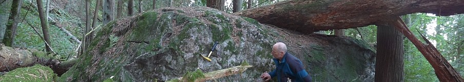
Keith Kemplin and vertical joints in Darrington phyllite along the track above the South Fork Nooksack.
There are two good references for the sequence of deformation events evident here. Brown (1987) has a great discussion of the subduction and lateral translation (‘Baja BC’) interpretation of the entire Northwest Cascades System, which includes the Easton Suite. A sketch of the phases of the deformation in the phyllite is in Dragovich and others (1998), with explanations of each stage on pages 36-37. The report discusses the deformation history of the phyllite, but the mapping does not extend to the Middle Fork Nooksack.
REFERENCES:
Beck, M.E., Jr. and Noson, L., 1972, Anomalous paleolatitudes in Cretaceous granitic rocks: Nature Physical Science, v. 235, p. 11–13.
Brown, E.H., and others, 1986, Geologic map of the northwest Cascades, Washington: Geological Society of America, Map and Chart series MC-61. Map and explanatory pamphlet.
Brown, E.H., 1987, Brown 1987: Geological Society of America Bulletin, v. 99, p. 201-214.
Dragovich, J.D. and others, 1998, Open File Report 98-5: Geologic Map and Interpreted Geologic History of the Bow and Alger 7.5-minute Quadrangles, Western Skagit County, Washington: Division of Geology and Earth Resources, Department of Natural Resources. Includes geologic maps and accompanying text. Scale 1:24,000
Dragovich and others, 2002, Geologic map of Washington- northwest quadrant: Washington Division of Geology and Earth Resources Geologic Map – 50. Map and explanatory text. Scale 1:250,000. Download is the map only.
Engebretson, D.C., Cox, A., and Gordon, R.G., 1985, Relative motions between oceanic and continental plates in the Pacific Basin: Geological Society of America Special Paper 206. 59 p.
Gallagher, M.P., Brown, E.H., and Walker, N.W., 1988, A new structural and tectonic interpretation of the western part of the Shuksan blueschist terrane, northwestern Washington: Geological Society of America Bulletin Bulletin, v. 100, p. 1415-1422.
Tabor, R., Haugerud, R., Hildreth, W., and Brown, E., 2003, Geologic map of the Mount Baker 30- by 60-minute quadrangle, Washington: Geologic Investigations Series I-2660. US Geological Survey.

Hey, I have always known you as a volcanologist/geomorphologist/glaciologist! Are you really a closet metamorphic (metaphoric!) petrologist and structural geologist?
Great detail, Dave, about a rock that is, as you say, quite conspicuous in Whatcom and Skagit Counties.
No, I’m not much of a structural geologist. That field always confused me, and it is one reason I wanted to write up these rocks. No better way to learn than to try to educate others. I’ll probably get some comments on this trip, Doug. You should have read the email exchanges I had with people who DO know about this stuff, in order to check interpretations, metamorphic concepts. I did a lot of editing before publishing this.
[…] randomly chose the photo at right from the archives. It was originally posted with the Pholiated Phyllite field trip in the South Fork Nooksack above Acme back in spring 2010. The exposures are probably […]