

Glacial drift, bluff erosion, concretions, and an intruding dike
By Dan McShane with revision and comments by Dave Tucker; originally written by D. McShane and posted on Reading the Washington Landscape blog, September 11, 2010. New photos and a comment or two from Bob and Adena Mooers were added in September 2011.
October 21, 2010
Introduction by Dave Tucker

Concretions: the 'nodules' of Nodule Point. B. Mooers photo. Click to enlarge images.
Here’s a geology field trip for beach walkers, to Nodule and Lip Lip Points on Marrowstone Island, south of Port Townsend. I have cribbed it (with permission) from Dan McShane’s blog, Reading the Washington Landscape, though I have added some material and an additional figure or two after discussions with him, and a few comments of my own in italics. I have changed a couple of Dan’s terms to match them with terms used previously on this website. See Dan’s original trip writeup here, and by all means subscribe to his entertaining blog while you are there. Dan is a professional consulting geologist with his own company, Stratum Group, in Whatcom County. He presents a fine example of putting a hard-earned WWU Geology Masters degree to good use. He is also a former Whatcom County council member, and sorely missed as a voice of reason by me, for one. But, I won’t go getting political on you, never fear. I haven’t done this trip, and solicit comments from readers who do go, or who already have. In particular, I’m interested in the big dike that cuts the sedimentary strata just south of Nodule Point. Before I reprint Dan’s excellent field trip, I’ll make a few comments. The features on this field trip can be seen individually in other places. A good place to see concretions is Silver Creek, just south of Bellingham, described in Northwest Geology Field Trips. The beach bluffs, dominated by till, are a little different from those across Admiralty Inlet described at Double Bluff or at Blowers Bluff, north of Coupeville, which are mostly interglacial sediment with till at the top. Beach bluff erosion is common up and down the bluffy coast of the Salish Sea, but to have it beginning to encroach on an old cemetery, as it does north of Nodule Point, presents an interesting problem for the near future (geologically near, for humans, ten plus whole years before someone has to do something).

Baked zone in the sandstone at the margin of the dike. Dan McShane photo.
I think the most appealing feature of this hike is the basalt dike just south of Nodule Point. I can think of very few places in the lowlands where a dike and its baked host rocks can be seen with such relative ease. It is still a 4-mile round trip beach walk, however, but hey, no hills. Perfect for a low tide outing. If you do this hike, please take pictures and notes and let me know. Contact me via my WWU geology department email: tuckerd at geol dot wwu dot edu.
Without further ado, here is Dan’s field trip to Nodule Point and beyond to Lip Lip Point. All the on-site photos are his.
I (Dan) previously did a post on Indian Island in Jefferson County. Marrowstone Island is another Jefferson County island immediately to the east. Marrowstone is accessed via State Highways 20, 19, and 116; the latter crosses the south end of Indian Island and crosses no more than a culvert onto Marrowstone Island. Fort Flagler State Park is on the north end of the island and includes old army houses that can be rented, with spectacular views. This fort (1897-1954) is one of several that were built to prevent a naval invasion of Puget Sound. Any navy be it Spanish or Japanese would have faced a gauntlet of hardened rifled cannons if they tried to enter Puget Sound. Another day use state park is at the lovely Mystery Bay on the islands west shore and the State Parks owns a large undeveloped parcel on the southern tip of the island.

South end of Marrowstone Island, from Google Earth. Click to enlarge any image.
Marrowstone is mostly rural, large lots with a few pasture farms. Up until a few years ago a common sight on the island were signs in favor and signs opposing public water on the island. Being an island in an area with relatively low rain fall combined with unfavorable geologic conditions water availability has limited development on the island such that properties that would otherwise have homes did not because there simply was not adequate water. A couple of years ago public water was extended onto the island so additional homes will be built and existing homes that had water problems again have potable water. The area is still rural and zoning on the island is such that for the most part there will not be huge changes in the short-term. I did note recently that the assessed value of a large property on one area of the island had increased dramatically after water became available.
Getting there: From WA 20, 4.7 miles south of Port Townsend, turn east on WA 19. If you are coming from the US 101 to the south, head north on WA 20 for 6.2 miles and turn east on Four Corners Road, which joins with WA 19. Take WA 116 east, pass through Hadlock, and cross the high bridge over the canal onto Indian Island. The road hugs the south shore of Indian Island, then crosses a narrow tidal slough to reach Marrowstone Island. Drive north along the west shore of the island on 116 past the hamlet of Nordland on Mystery Bay and turn right onto East Beach Drive. Follow this road 0.3 mile Jefferson County’s East Beach Park. From there, the hike goes south down the beach along the east side of the island to Nodule Point. The hike from Beach Park to Nodule Point and back is approximately three miles with no hills as it is entirely on the beach. Check the tides and do this hike during an ebbing tide. At high tide, the water does not reach the toe of the slope very often, but there are a few areas where trees grow along the shore and they extend out over the beach. There are a few stairs to the beach from properties as well as a tram just south of the dike at Nodule Point so there are a few escape routes in case of tsunami.
The first part of the hike provides great exposures of Vashon-aged glacial drift*. The bluffs consist of advance outwash (the Esperance Sand), often cross bedded, capped with glacial till or glaciomarine drift. The outwash consists mostly of sand that was deposited by outflowing glacial streams as the glacial ice advanced southward into what is now Puget Sound, approximately 20,000 years ago, during the last great glacial advance; glacial ice was gone from the Marrowstone area by about 13,000 years ago. The till was deposited directly by the glacial ice as the the advancing glacier covered, and then receded from, the area. The till consists of an unsorted mix of sand, gravel and silt with an occasional boulder along this reach of shoreline. Because the sediment is derived directly from the ice, the grains have not been sorted by flowing water in sharp contrast to the well sorted underlying sands with a few thin silt layers in the outwash beneath the drift.

Two drift units: Massive ('structureless') Vashon till overlies Everson Sand (outwash). A. Mooers photo.
*Dave’s terminology digression: ‘Drift’ is material deposited either directly from ice or from meltwater issuing directly from ice. Drift includes ’till’, which is laid down directly by ice without any intervening water transport, but drift also includes outwash gravel and sand deposited by streams flowing outward from the front of the glacier, and glaciomarine drift (gmd), which is sediment that rains down from floating ice to the floor of the sea or a lake. To be recognized unequivocally as gmd, fossil shells of clams or other molluscs in growth position, meaning intact with hinges closed, and not arguably remobilized from some other deposit, need to be present. They are often pretty scarce and require persistent, diligent searching. Dropstones that fell through water and deformed clay on the floor of a body of water could be present in either marine or lacustrine drift. Scroll to the end to see a photo of a dropstone. All till is drift; not all drift is till. Got it? End of digression. Let’s get back to the field trip.)
Beside the very good exposures of drift and outwash, this bluff provides excellent examples of shoreline bluff erosion. The first few times I had been on this shoreline most of the sloping lower bluff slopes were grass-covered with a few small Douglas fir trees. Four winters ago a large low pressure system combined with a very high tide and high winds caused extensive erosion along this reach of shoreline. A similar event took place this last winter as well. The erosion caused most of the lower portions of the bluff to become over steep and led to sloughing of the loose sand. This further undermined the very hard compact drift which holds vertical cliff faces and subsequently slabs of drift have calved off of the upper slope onto the slopes and beach below. Various stages of bluff recession can be seen all along the bluff for the first mile of this beach walk.

The dark curtain of roots once filled a crack in the bluff, now collapsed. A. Mooers photo
One interesting site is a spot where the glacial drift is particularly thick. (48° 2.732’N, 122° 41.012’W). A chain link fence can be seen from the beach below looking up at the top of the slope. Behind this fence is a cemetery. An interesting future problem with bluff recession I have estimated at 2 inches per year. You can recognize this spot from the beach by a remarkable exposure of the roots of a tree- until the tree pitches over the bank.
A little past the cemetery the outwash unit pinches out and the glacial drift becomes bouldery and a little further on bedrock crops out above the beach level. Glacial drift is often composed predominantly of the local material immediate beneath the ice. So where the drift up to this point on the walk was sandy due to the underlying outwash sand it now is boulder- filled reflective of the underlying bedrock.
The walk reaches bedrock of the middle- to late Eocene (about 45 million years old) Scow Bay Formation (Allison, 1959) at Nodule Point. The point was originally named Nodule Point by British explorer George Vancouver. The American Wilkes Expedition named it Ariel Point. However, the U.S. Coastal Survey went with the more descriptive (but geologically incorrect: what do they know, anyway dt) name of Nodule Point.

Concretions in Scow Bay sandstone at Nodule Point. It appears as though cannon balls are preserved form a naval battle. B. Mooers photo.
To be clear these geologic features are concretions, not nodules. Nodules involve actual replacement of the parent material with new minerals. The concretions form as a result of different cementation often because of impurities within the sand- or siltstone that act as nucleation sites for carbonate to precipitate. Small bits of mud stone surrounded by harder rock are present within this formation. As the rock is eroded, the harder cemented sections stand out as hard knobs from the surrounding softer rock. These concretions are very common in the sandstones in rocks in this area, but this is one of the better sites for observing them. The concretions range up to sizes a bit larger than bowling balls and most are round. For another nice concretion locality, see the field trip to Silver Creek in the Chuckanut Formation, near Lake Samish. (Northwest Geology Field Trips).
The Scow Bay Formation is located along the southwest coast of Marrowstone Island, and is primarily marine arkosic sandstone, interbedded with tuffaceous shale. The formation likely overlies the Crescent Formation basalt and was deposited near or shortly after the end of the Crescent sea floor basalt lava flows. Uplift of these rocks is the result of accretion of ocean sediments and up lift of the Olympic Mountains approximately 7 to 12 million years ago.

The dark rock at left is the mostly eroded basalt dike, in contact with lighter sandstone at right. B. Mooers photo.
An intriguing feature of the bedrock on Marrowstone Island is that bedrock is found along the shores south of the hamlet of Nordland, but to the north the depth of bedrock is greater than 1,500 feet with no wells penetrating to the bedrock suggesting a major preglacial structure that happens to align in a parallel manner with faults to the east suggested on Whidbey Island.

Basalt of the dike. Dan McShane photo.
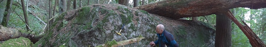
The highlight of the trip is a little bit south past the point. A few hundred feet to the south a 20-foot-wide vertical dike of basalt intrudes through the sandstone (48° 1.853’N ,122° 40.128’W). The two wall-like outcrops shown in the accompanying Google Earth image that protrude across the beach are the baked sandstone that sandwiches the dike. The dike is eroded away between these two walls, and does not extend much onto the beach. It really is a cool example of preferential erosion, with the fractured dike being more easily eroded by the waves than the hornfelsed (heat hardened, low-grade metamorphosed) sandstone on either side of the dike. (DT has added: I found out that the dikes on Marrowstone were discussed in a paper by Scott Babcock, Chris Suczek, and Dave Engebretsen in 1994, and previously in a WWU MS in 1984 by L.A. Melim. Babcock and others (1994) say that Melim said that the dikes [there are ‘several of them’, apparently] are “petrographically similar to subaerial Crescent flows exposed near Port Ludlow, so the Scow Bay sandstones could be intertongued with upper Crescent.” ) The dike is associated with a late stage of volcanism associated with the massive out-pouring of magma of the Crescent Formation basalt that underlies most of the north and east side of the Olympic Peninsula. I would emphasize low tide for this part of the hike. The harder sandstone along with its concretions juts further out from the land and depending on the tide may require getting wet to get past like I did on the day I did the hike.

The strange 'lip' concretions at Lip-lip. D. McShane photo.
If you do this walk you may want to continue to the south to Liplip Point (48° 1.046’N,122° 40.212’W) where lip- shaped concretions are common and on occasion some good birding as well (see an earlier post). I have been to Nodule Point on five occasions and have never seen anyone there. A few people will be around the beach near the county park depending on the weather. But even then the beach traffic can be interesting. Lots of deer use the beach as a trail and on this trip I nearly stepped on a seal pup as I was looking at the geology and not where I was walking. It can be also be a great spot for watching ship traffic as this is the passage into Puget Sound.
See more photos from Dan below.
References
Alison, R. C., 1959, Geology and Eocene megafaunal paleontology of the Quimper Peninsula area, Washington. M.S. thesis, University of Washington, 121 p.
Babcock, R.S., Suczek, C.A., and Engebretsen, D.C., 1994, The Crescent “Terrane”, Olympic Peninsula and southern Vancouver Island: in Regional Geology of Washington State, Washington Division of Geology and Earth Resources, Bulletin 80, p.141-157.
Sinclair, K.A. and Garrigues, R.S., 1994, Geology, Water Resources, and Seawater Intrusion Assessment of Marrowstone Island, Jefferson County, Washington: Water Supply Bulletin 59, Washington State Department of Ecology. 83 pages
The first third of Sinclair and Garrigues is a description of Marrowstone geology, including photos of some features along this stretch of shore. It is available on line at http://www.ecy.wa.gov/programs/eap/wsb/pdfs/WSB_59_Book.pdf
Dan sent me some additional really cool photos that weren’t on his original blog entry.

Volcanic ash layer from an unknown eruption in marine or lake sediment at Lip Lip.

A dropstone in glaciomarine drift. These stones are evidence that thin ice was floating as the glacier receded.

Thin, undeformed clay beds overly massive till. Following retreat of the Vashon glacier, fine sediments covered the sea floor. The sea floor was raised during isostatic rebound.

Has anyone ever cracked one of those concretions to check for crabs, ammonites, or nautiloids? Tim Fisher’s Ore-Rock-On DVD lists some sites to the north that featured nautiloids, I believe.
I don’t know. I say get busy, man!
DT
To each geologist, his own addiction. You love your igneous dikes, and I’m a sucker for a cannonball… now I’ll be hearing Peter, Paul, and Mary singing “If I had a hammer…” the rest of the day.
Dang you Garret, now I will too!
DT
Is nodule point PRIVATE beach property? We went yesterday and on either side of East beach park has private property signage. So how did u get to nodule point? The beach on fort flagler only goes so far. We want to explore nodule but what do we need to do to access it?
Get onto the beach at East Beach Park and walk along the water. Pay attention to the tide. I have never heard of anyone being harassed by upland property owners on this walk. I have done it several times. Have never seen a soul.
Found a concretion at a hill near my home.It is in the shape of a canon ball.It appears to have many layers.I would like to know more about it.
Rajashree, where do you live? would be interesting to know which sedimentary rock unit is found where you live. Round concretions are pretty typical. They generally are formed by very local intense cementation as fine sandy sediment is lithified [turned to rock]. Often the source of the cement is a mollusc or crustacean shell that dissolves and adds extra calcium to the surrounding sediment via diffusion. This calcium more thoroughly cements the sand grains surrounding the shell. The shell often completely dissolves, leaving little if any trace.
Well blow me down! I am Puget Sound Tugboatman and have been passing by Nodule Point for the last 40 years and now you tell me that there are nodules at Nodule Point and lips at Lip Lip Point!!! Outstanding!! ( By the by, Nodule Point is a southbound Radio Channel VHF 05A/ 14 Check-In point for Seattle Vessel Traffic Service.)
Ahoy matey! Thanks for writing and subscribing. You might also like to know that there is nothing at Point No Point. Ha ha. DT